Luckily, I discovered the website Ride With GPS. I can create routes, download them to my phone and bike computer, and do some map recon ahead of time.
(You can do a bunch of stuff with the free version, but I did the basic upgrade for $5/month)
Step 1 - Determine how far the ride was to determine a daily average
If you are staying within certain countries, you can do this on Google, but that wasn't an option for me. So I inputted my home address and my finish location into Ride With GPS and voila! It calculated the most direct route was 1400km.
Now it is time to look at that route with a critical eye. The shortest route involved riding through the part of Russia that is between Poland and Lithuania, so that is out. So I dragged the route west until I was not going through that section.
It would also be a good idea to double check the route for road types. I will be riding a road bike, so I am trying to avoid gravel paths if possible. Ride With GPS has different map views that can be helpful in determining the road surface. But I was generally looking at staying on more major roads. When I write about the daily route planning, I'll go into much more description about this.
Another major point for me was figuring out exactly where to cross the Poland/Lithuania border. There are basically two major routes that are both European highway routes (the E routes). I know from travelling there before that they are really busy with truck traffic and I would want to avoid them if possible. Doing my map research and Google Street View research, I found another way less congested place to cross. So I altered my whole route to go through there as well.
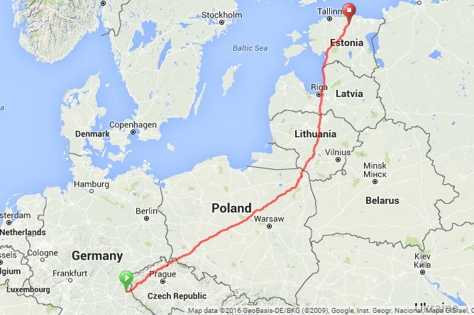
So now I look at my total: 1704km. Over 14 days, that averages to 121km a day (about 73 miles). Since I am going to give myself a rest day, plus I want my final day to be short, I will need to aim for about 135km/day.
I then created a spreadsheet to determine what my goal distance marker was for each day to get a rough idea of where I would be stopping.
In doing my research, I found this YouTube video to be very helpful. He discusses his route planning, and that is how I based my plan. https://www.youtube.com/watch?v=4NJNI-gOLVg
(The video is pretty long...he starts talking about route planning at 35:00)
Later, I will discuss how I nailed down each route for the day and made some modifications to this "Master Route."